


Airmate

Beschreibung von Airmate
Airmate ist ein kostenloses und benutzerfreundliches Electronic Flight Bag für Piloten, das Hilfe bei der Flugplanung und Navigation bietet und viele Funktionen zum Teilen in sozialen Netzwerken enthält.
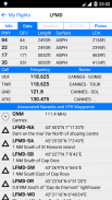
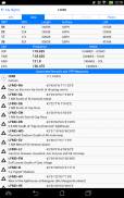
Dank Airmate erhalten Sie sofortigen Zugriff auf Flughafendaten und Luftfahrtkarten weltweit, aktuelles Wetter und NOTAMs.
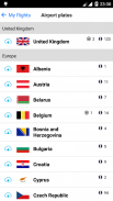
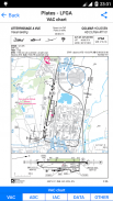
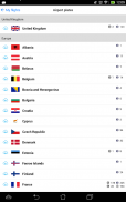
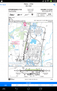
IFR- und VFR-Flughafendiagramme und -tafeln sind in den USA, ganz Europa und mehr als 200 anderen Ländern frei verfügbar. Viele von ihnen sind georeferenziert und könnten auf der Luftfahrtkarte eingeblendet werden. Ein leistungsstarker Kennzeichen-Manager ermöglicht es, alle Flughafenkennzeichen in einem Land im Voraus herunterzuladen, sie können einfach ausgedruckt und angezeigt werden.
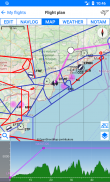
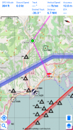
Während des Fluges zeigt die Moving Map den Standort des Flugzeugs entlang der Route, zeigt Flughäfen und aeronautische Datendetails. Eine Profilansicht ist verfügbar, um Geländehöhe. Airmate kann mithilfe der geräteinternen Sensoren auch eine Lageanzeige und Flugparameter eines Backup-Flugzeugs in einer EFIS-ähnlichen Ansicht anzeigen
Airmate enthält eine weltweite Luftfahrtdatenbank, die kostenlos mit Flughäfen, Navigationsbaken, Wegpunkten, Luftwegen, Hindernissen, regulierten und eingeschränkten Bereichen aktualisiert wird. Topografische Karten und Höhendaten für die meisten Länder sowie zusätzliche Luftfahrtkarten-Overlays können kostenlos heruntergeladen werden.
Airmate zeichnet Ihre Flüge auf und ermöglicht es, sie später wiederzugeben oder den Flugweg im gpx-Format zu exportieren.
Ein Satellitenkarten-Anzeigemodus im Flugplanungs- oder Wiedergabemodus ermöglicht es, sich mit wichtigen Orientierungspunkten vertraut zu machen.
Airmate speichert geplante und geflogene Flüge, Benutzerwegpunkte und Benutzerflugzeuge in der Cloud und synchronisiert sie zwischen Ihren Geräten und der Airmate-Web-Flugplanung.
Airmate bringt zahlreiche soziale Funktionen in die Community. Piloten können Bewertungen, Tipps und Kommentare hinterlassen, um ihre Erfahrungen auszutauschen und Treibstoffpreise und Landegebühren zu melden. Sie konnten Freunde, Ausbilder, Flugschulen, Luftfahrtveranstaltungen und Flugzeuge zum Mieten in der Nähe ihres Heimatflughafens oder eines besuchten Flughafens finden.
Airmate kann mit den meisten Flugsimulatoren verbunden werden, um die Flugfähigkeiten auf dem neuesten Stand zu halten.
Airmate – Version 1.7.6
(04-06-2025)
Airmate – APK Informationen
APK Version: 1.7.6Paket: com.aero.airmate.airmateNeueste Version von Airmate
Weitere Versionen


Apps in derselben Kategorie

Das könnte dir auch gefallen...


